Wildfire Readiness
When we think about wildfires, we tend to think about Eastern Washington and not the westside. However, the combination of dense forest, dryer summer weather, a growing population, and housing developments built up against wildland areas can increase the threat of wildfires making it a risk for Western Washington as well.
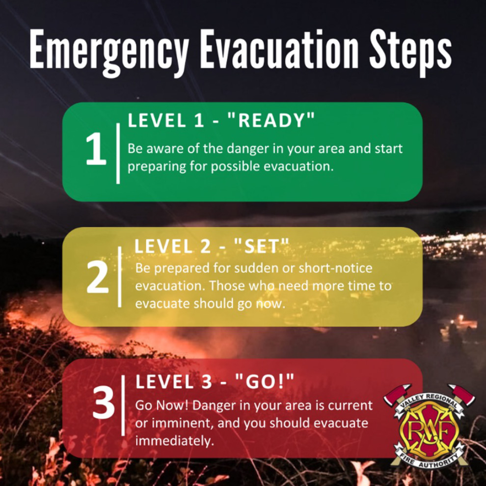
Please review the resources below to help you and your family prepare for wildfire, and any emergency that may require evacuation.
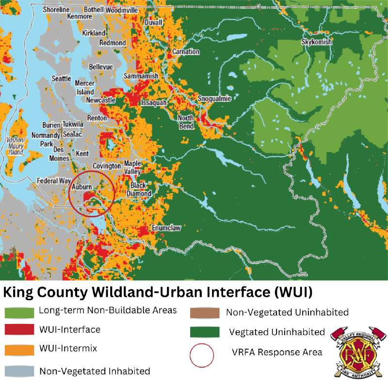
What is the Wildland Urban Interface (WUI)?
The wildland/urban interface area (WUI) is the zone of transition between unoccupied land and human development. It is the line, area or zone where structures and other human development meet or intermingle with undeveloped wildland or vegetative fuels. There are several locations within Auburn where structure developments meet and blend with the wildland areas. This brings the possibility of interface fires, especially when weather conditions become dry and an abundance of fuel is present.
Is your neighborhood in the WUI?
If you live within VRFA’s service area, your home could could be located within the WUI- but it is important to remember that WUI is only one component to assessing risk and should not be considred the sole measure of wildfire risk. The WUI is where additional protective actions benefit those living in these areas by creating defensible space around their dwelling.
Identifying fire risks and mitigating them will go a long way toward reducing the impact wildfire can have on your home, property, and your community.
Wildfire Readiness
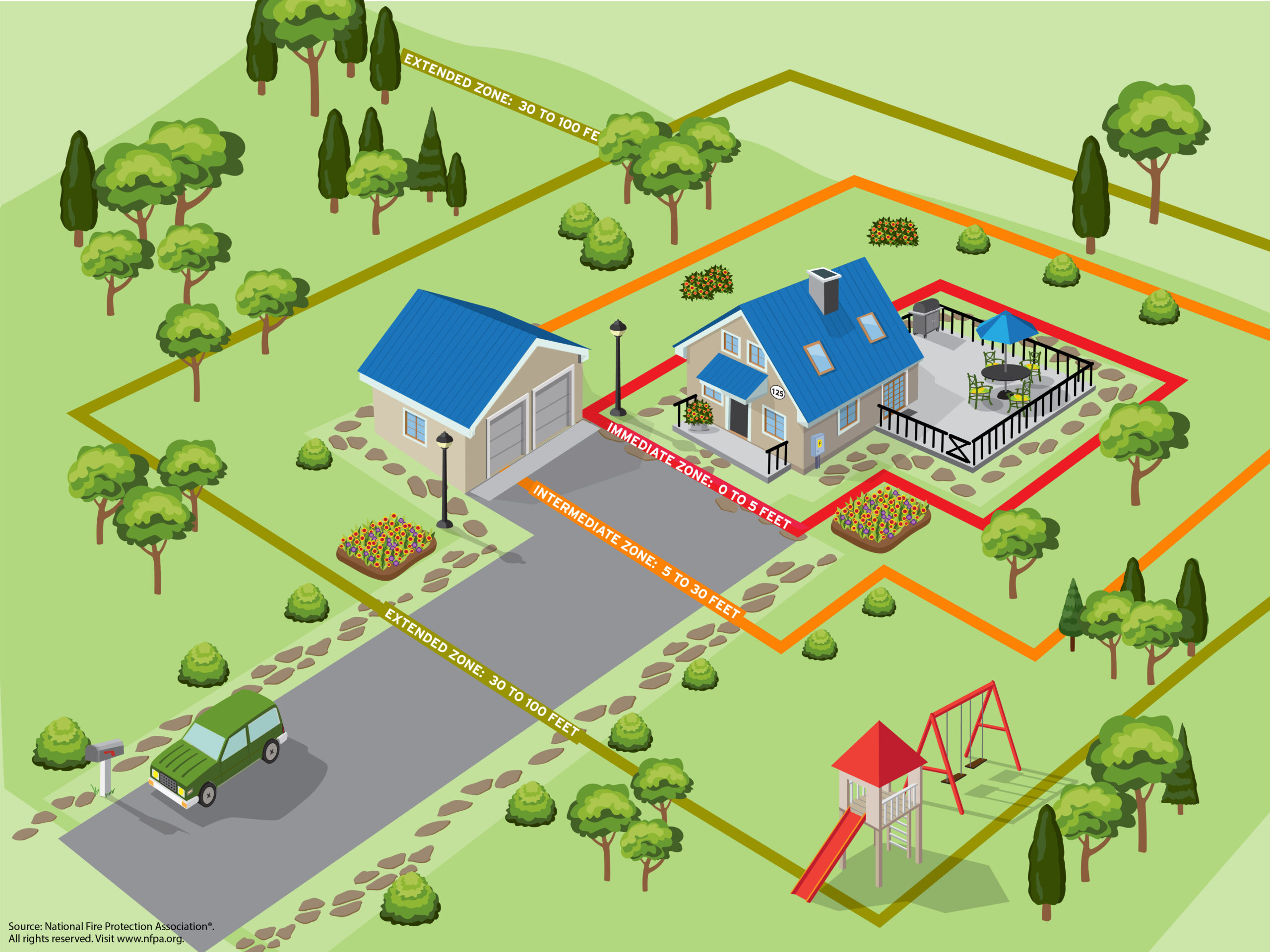
Wildfires can occur anywhere and anytime. Living with fire means being ready and being ready starts at home. YOU have the power to make a difference in protecting your home and property. This starts with the Home Ignition Zone Preparation Checklist (HIZ). The HIZ is a buffer of up to 200 feet around your house. It is the defensible space where you can create a safety buffer to give your home the best chance of surviving a wildfire. Maintaining the Home Ignition Zone can slow or stop the spread of wildfire, defend your house from fire, heat radiation, and embers, and protect firefighters.
The National Fire Protection Association (NFPA) divides the Home Ignition Zone into three sections.
- The Immediate Zone (Red 0-5 ft)
- The Intermediate Zone (Orange 5-30 ft)
- The Extended Zone (Green 30-200 ft)
Please check out our Wildfire Readiness Checklist
Immediate Zone
The home and the area 0-5’ from the furthest attached exterior point of the home; defined as a non-combustible area. Science tells us this is the most important zone to take immediate action on as it is the most vulnerable to embers. START WITH THE HOUSE ITSELF then move into the landscaping section of the Immediate Zone.
- Clean roofs and gutters of dead leaves, debris and pine needles that could catch embers.
- Replace or repair any loose or missing shingles or roof tiles to prevent ember penetration.
- Reduce embers that could pass through vents in the eaves by installing 1/8-inch metal mesh screening.
- Clean debris from exterior attic vents and install 1/8-inch metal mesh screening to reduce embers.
- Repair or replace damaged or loose window screens and any broken windows screen or box-in areas below patios and decks with wire mesh to prevent debris and combustible materials from accumulating.
- Move any flammable material away from wall exteriors – mulch, flammable plants, leaves and needles, firewood piles – anything that can burn. Remove anything stored underneath decks or porches.
Intermediate Zone
5-30’ from the furthest exterior point of the home. Landscaping/hardscaping – employing careful landscaping or creating breaks that can help influence and decrease fire behavior.
- Clear vegetation from under large stationary propane tanks.
- Create fuel breaks with driveways, walkways/paths, patios, and decks.
- Keep lawns and native grasses mowed to a height of four inches.
- Remove ladder fuels (vegetation under trees) so a surface fire cannot reach the crowns. Prune trees up to six to ten feet from the ground; for shorter trees do not exceed 1/3 of the overall tree height.
- Space trees to have a minimum of eighteen feet between crowns with the distance increasing with the percentage of slope.
- Tree placement should be planned to ensure the mature canopy is no closer than ten feet to the edge of the structure.
- Tree and shrubs in this zone should be limited to small clusters of a few each to break up the continuity of the vegetation across the landscape.
Extended Zone
30-100 feet, out to 200 feet. Landscaping – the goal here is not to eliminate fire but to interrupt fire’s path and keep flames smaller and on the ground.
- Dispose of heavy accumulations of ground litter/debris.
- Remove dead plant and tree material.
- Remove small conifers growing between mature trees.
- Remove vegetation adjacent to storage sheds or other outbuildings within this area.
- Trees 30 to 60 feet from the home should have at least 12 feet between canopy tops.
- Trees 60 to 100 feet from the home should have at least 6 feet between the canopy tops
Sign Up For a Free Wildfire Home Assessment
The VRFA Wildfire Home Assessment program helps homeowners identify and understand potential risks posed by wildfire and learn what steps can be taken to reduce those risks.
Studies show that as many as 80 percent of homes lost to wildland fire may have been saved if defensible space had been created around them. We can help determine what preventative measures are needed around your home with a wildfire home assessment. Trained VRFA staff will survey your home and property and create a customized plan for you to improve your wildfire preparedness.
What Happens in a Wildfire Home Assessment?
VRFA staff will:
- Evaluate the potential for wildfire conditions in your area
- Identify your home ignition potential in the three home ignition zones
- Immediate Zone 0-5 feet (roof, eaves, exterior walls, windows, doors, deck)
- Intermediate Zone 5-30 feet (vegetation, outbuildings)
- Extended Zone 30-100 feet (vegetation, trees)
- The results of the assessment and specific mitigation recommendations will be compiled into a report and shared with you shortly after the assessment.
How to Get Started:
- Complete the Wildfire Assessment Request Form
- We will contact you to schedule your home assessment
- Your home will be assessed in approximately one hour
- You will receive a report with recommendations for wildfire mitigation
- Expect a follow-up contact to answer any questions you have and see how you are progressing
Need a tool to utilize for your Wildland Urban Interface Home project? Don’t have it? No worries! The South King Tool Library provides access and lends out tools for everyone to use to maintain their homes and spaces. We have partnered with SKTL in hopes that community members can have access to tools to conduct WUI home projects and be prepared to harden their home against wildfire.
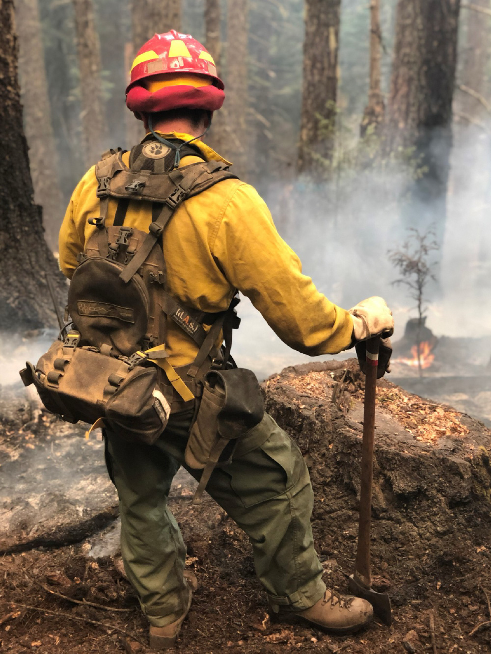
How We Prepare
The VRFA maintains a 20-person “Red Card” certified wildland fire team. Following certification, team members complete wildland firefighting refresher training and a challenging fitness test annually. This training is beneficial for wildland/urban interface fires in our service area as well as throughout the state and country. Our brush and tender trucks, along with our personnel, will respond within our service area, throughout south King County, the State, and outside the State through special deployment.
Each deployment takes team members away from the VRFA and their families, however, they gain valuable experience and knowledge. We hope we never have a large wildfire in our service area, but we know from past experiences like the Sumner Grade Fire and others that it is a possibility. If it does happen, our team members’ experience and knowledge will be valuable in protecting our communities. To learn more, view our photo diaries: Photo Diaries
Additional Wildfire Resources
- Alert King County
- Pierce County Alerts
- Firewise USA
- Home Ignition Zone Checklist
- King County Wildfire Readiness Toolkit
- King County Wildfire Risk Reduction Strategy
- VRFA Wildfire Readiness Checklist
- Washington State Department of Natural Resources
- Wildfire Ready Neighbors
- Wildfire Home Retrofit Guide
- King Conservation District Wildfire Mitigation Program